| Point Ferry—Alasra | Difficult | 4:00 | 5.89 mi |
This is tough in places because the terrain is uneven, with some scrambling over rocks, and stooping in hazel woods. Sheep paths still make this walk possible and the rewards are great.
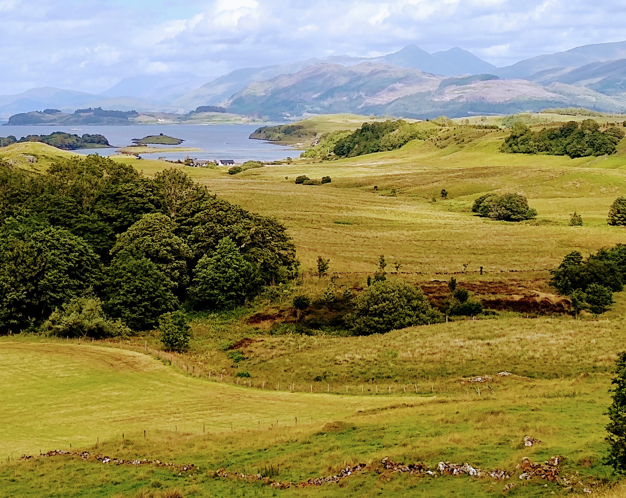
Alasra is a peninsula on the northwest of Lismore, beyond Port Ramsay and Laggan. It was originally part of an area known as Fennachrochan. It is stunningly beautiful and extremely interesting. As far as is possible, the walk follows the raised beach on Alasra.
1. Point Ferry to Port Ramsay
From the Point Ferry at the north end, take the main road south (or start anywhere on the route you happen to be). After 330 metres turn right onto a track and climb up, go through a gate and straight on. When you reach the top you are looking down at Morvern and the Glensanda Quarry in the far distance, but in the near distance, you can see a drystone wall. Aim for the break in this wall and, once through, climb up a rise, veering left, to reach a tractor path and a break in a lower wall. Straight on here.
Soon Glensanda is visible to the right in the far distance, Alasra in the middle distance and the houses at Laggan beyond. Continue ahead and slightly right. In the near distance are a fank and a rough cliff, a quarry for the lime works. Head for the fank and turn right onto the road, passing the two Park limekilns on your right just before a gate near the sea.


Turn left and walk in front of a new house, and then on past the Port Ramsay cottages. When you reach the end, turn sharp left beside the phone box, and take the first right onto a rough road to Laggan.
2. Port Ramsay to Laggan
From here to the end of this road is about a kilometre. Not far on you pass three broken-down caravans on your right, and later cross a cattle grid beside a dark house, and another after a white house. Follow the road round through Laggan, passing several houses, and arrive at a gate with a caravan beside it.
Through the gate follow the track beside a wall, passing a cabin up on your left, and in front of a large white house, Camas. Immediately past the house, a gate leads to the shore.
3. Alasra Pensinsula East
Very soon go through a smaller gate and turn right on a rough sheep path beside a fence. Depending on the time of year, this can be overgrown, wet and a scramble at times. A lot of seeking out the best route is required. Keep following the sheep track, and eventually you come to a quite large wall which is conveniently broken down. Cross it and continue for a bit before you need to climb up towards an outcrop. Pass to the left of this and follow the sheep path quite high here, and then down towards a stone building beside a limekiln, with boulders strewn below what was the quarry.
There is a path down to the remains of the quay where the lime was exported. The stone building was possibly a storehouse for explosives and other quarrying necessities. Lime burning was a significant activity on the island in the 19th century. Several walks have kilns.


Pass behind the stone building and climb up some jaggy limestone, and a little further on pass behind the remains of a dwelling, one of the gable ends covered in brambles; the other has a fireplace. Possibly the lime works manager’s house.
4. Alasra Peninsula Top
As you round the top of the peninsula, keeping to the raised beach, you will see Glensanda Quarry ahead on the mainland and a shingle beach in the near distance, before a sheep path takes you amongst hazel trees (a bit of stooping required at times). Out of the trees, you are above another shingle beach (Alasra has many small bays with shingle beaches). Climb down on convenient limestone steps, and continue ahead just above the beach on a clear sheep path.
Climb again to reach a relatively flat place and ahead on a promontory, near the shore, is a rusty white gas beacon whose origin is still a mystery despite consulting many of the older Liosaich. It is generally agreed to be post-Second World War and has a plaque saying: Gas Accumulator (something), Lighthouse (something), Beacon Works, Brentford, England. It stands on a large white arrow pointing north-west, which may or may not be significant. I’m told that when there was a gas cylinder within (it is empty now) it had a considerably long life, but no one is able to tell me when it stopped working, or what it did. My guess is that it is a cold war item and was to do with submarines. All suggestions welcome.
You can walk across this flat bit and look at the beacon.


Otherwise, continue under the cliff, passing a ruin on the left (possibly a place where horses were kept) and walking southwest towards some trees. Down on your right, a little bit away, is another beach. Continue ahead and see another wee bay quite soon.
5. Alasra, heading south west
A sheep path will take you into more hazel trees which are penetrable but difficult. At times you need to force your way through. Seeing wool on the ground or snagged on bushes makes finding the paths a little easier. Eventually, you are out of the trees, and climb down to a beach which is accessible at most tides, but at the very highest you may have to find a higher route.
Follow the sheep path along the shore for a while and until it leads into the trees again through a rather concealed entrance above limestone ridges. As the hazel thins out, leave the sheep path and move towards a lovely cliff on a corner and then you are onto another sheep path into more hazel trees
Once out of this you are beside another beach. Clamber down and cross in front of it, the nearer the sea the better, as the terrain is uneven, and there are ditches covered in vegetation which may be invisible.
At the end of the beach climb up and enter another hazel wood. After a short time you will see daylight on your left, so leave the wood, clamber over some rocks and follow the sheep path into the wood again. This can be very boggy in places, but once out you see yet another little bay to which you climb down.


Once over the beach, climb up and enter the wood again. Continue walking round above the bay, and you come to a wall which goes down to the sea. Walk along on the left of this.
6. Laggan
Eventually you come to a fence you can easily clamber through, and immediately climb down the broken wall and turn left. Go straight ahead under the raised beach cliffs, then cut up to the left on a rather wet path and, when you see a wall ahead, follow it round and walk parallel with it and, when it turns, continue up the hill until you are walking beside it.
Soon you arrive at a gate. Leave it as you find it, and go through on to an easy tractor track, keeping to the left down the field as there is a burn to cross.


Once over the burn, walk diagonally down the field and turn right in front of Camas, where you started. Follow the road to Port Ramsay.
7. Port Ramsay to Point
When you arrive at Port Ramsay, turn right onto the road and, after a short time, cross a cattle grid, and then meet the main road at Stronacraoibh. Turn left on the main road and stay on it until the ferry.
Historical note: It is not thought that Alasra (there are many spellings) was ever lived on, although sheep have always grazed it since they have been here. The most famous traditional story concerns Donald Campbell of Ardnamurchan, a most unpleasant lot, who had acquired land in Lismore in the 17th century and of course wanted more. To this end, he tricked the Livingstones of Bachuil out of considerable land by insisting that the entire island attend his church service and, while they were there, an accomplice (who later killed himself) caught and killed the prized black sheep of Alasra and hid the carcass in the Livingstone’s barn. Not wanting to be accused of sheep stealing, the Livingstones agreed to forfeit most of their Lismore land, retaining only around a dozen acres.