| St Moluag’s Trail | Moderate | 2:35 | 6.01 mi |
|---|
Introduction
Moluag died in 592 on 25th June, now his commemoration day. This walk can be done comfortably between the normal ferry service leaving Oban at 0900 and returning at 1500. (It’s not always normal.)
1. Achnacroish
Start at Achnacroish where the car ferry from Oban arrives. Walk up the main road past the welcoming phone box on the left which sometimes has baking from the Dutch Bakery on Lismore and always has books about the island from Camelart, plus visitor guides and general information. At the top of the hill pass the school.
Lismore Primary School opened on this site in August 1965. The 1872 Education Act provided state-sponsored schools, with compulsory attendance for all children aged five to 13. Lismore previously had two schools, one at Baligarve and one at Baligrundle. Those who went on to Oban High School were away from home from the age of 11 or 12 as they are today. Sadly, at that time, not all scholarly children were able to go to the high school. With improved ferry services, it is now possible to travel daily.
Continue beyond the school, seeing high in a field on the right the remains of the World War II lookout. Almost immediately you reach a square white building. Turn right, following the track past the house through the farm and beside a wall which soon becomes a fence. You are making for a sturdy stile in a wall ahead which leads into Balnagown. In the distance, before you cross the stile, is a clump of trees. Aim for the left of the largest one. There is a burn to cross before the stile, so find the narrowest part.
Once over the stile, climb up the field, veering slightly left towards the trees, and you will see a small gate in a wall. Just before this gate are the ruins of Connel’s Croft, the Connel family having been boatbuilders. The remains of their saw pit and workshop will be seen at Port Moluag later on this walk.


2. Balnagown
Through the gate you are in Balnagown. Go straight ahead towards a clump of trees and to the left of these through another gate. Follow this road beside a wall on your left which leads to yet another gate and eventually to the main road. Near the end it curves round to a cattle grid but, if you prefer, before this curve you can walk ahead down a grassy slope to a small gate opposite Lismore Stores, handy for anything you may need and open every day except Sunday with half-days on Wednesday and Saturday.
From the shop, or the cattle grid, join the road heading north. The Heritage Centre is soon visible on your left and here, in season (beginning of April to the end of October), you can read about St Moluag and the importance of the Christian church of Lismore, and also visit the cafe for refreshments.
3. Clachan
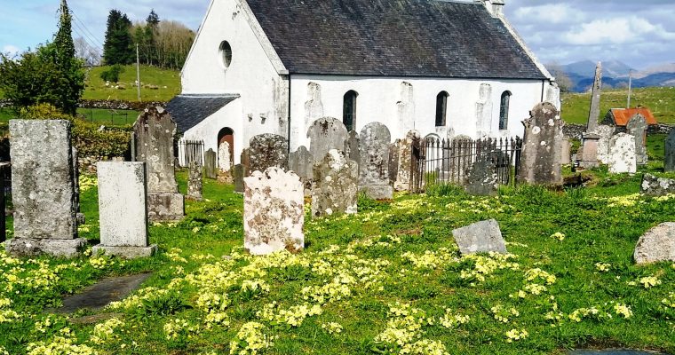
From the Heritage Centre turn left onto the main road and continue north, passing the fire station and the telephone exchange on your right and, as you enter Clachan, you will see the new manse (a bungalow) also on the right and in the field before it the sanctuary stone (Clach na h-Eala/idh), said to be a refuge for fugitives fleeing from the Hill of Justice some miles away. If they reached the stone and circled it they were given sanctuary. It is a granite erratic which had mythic status in pre-Christian times. On your left, just after the war memorial, are the mounted medieval grave slabs with information boards.
Clachan is where, in the sixth century, Moluag chose to have his Celtic muinntir and where, around 1200 AD, Duncan MacDougall was instrumental in having the new Diocese of Argyll based on Lismore. They built the chancel of the new cathedral in the second half of the 13th century and dedicated it to St Moluag. However, the site is thought to have had religious significance back to worship in the Bronze Age. Information boards outside the church provide more detail.
The surviving structure, cut down from the medieval chancel, has undergone at least two major refits over the last 250 years, the first in the 1740s and then around 1900, resulting in the present parish church. The church is open and you can see what remains of the original building. The old graveyard is also worth a visit.
4. Baligarve
Continue north on the main road passing Bachuil House on your left, home of the Livingstones, the keepers of Saint Moluag’s Pastoral Staff known as The Bachuil. It is reputedly made of blackthorn and today measures 2 ft 9 in (0.79 m). At one time it was encased in metal and perhaps studded with jewels. Now only fragments of metal adhere to it.
Baligarve farmhouse and the old Baligarve schoolhouse are soon on the left and on your right, just beyond the brow of the hill, Lismore Luminations’ honesty box. Just after a bungalow on your left is St Moluag’s Chair, in fact a chair-shaped rocky outcrop where he is purported to have sat and contemplated. Look out for this as it is just over the stone wall and the sign may be down as livestock are prone to using it for whatever.
The next right turn is into the Balure Road, signposted Balure and the Broch. This leads down to Bailuacraich farm and Eilean Dubh (the Black Isle) in the Firth of Lorn. After the next bungalow on the left is the road to Port Moluag. Turn here, passing the sign for Port Moluag house but leaving the road halfway down and walking towards the bay.
The port is more an indent in the coastline than a serious place to land, but is significant as it is said to be where Moluag (later a saint) landed, from Ireland, in 562 AD as one of the proselytising workers of the early Christian church. He travelled with his twelve apostles and set up a monastic community known as a muinntireas. He also set up similar centres at other places in Scotland and travelled a great deal; his name is known from Lewis to Aberdeen to the Isle of Man. As Donald Black said: ‘Truly he was just as important as Columba in the early Celtic church but is not as well known. Of course not being of noble birth and not having a biographer as a relative was a distinct disadvantage.’
Moluag’s ministry eventually spread throughout much of what is now Scotland and northern England, or so the story goes. Evidence is necessarily sketchy. This area was also the site of an ancient chapel, possibly the original place of worship established by Moluag before he selected Clachan. The freshwater spring, known as Tobar na Slàinte, was also linked with him.
The remains of the Connel boatbuilding station are still visible on the raised beach. The story of this family is told on the Comann Eachdraidh website. Over to the right is a newly built house and the original croft house is tucked into the hill. Both are second homes or holiday accommodation.


5. Balure and Tirfuir
Retrace your steps and turn left onto the Balure road and continue to a gate into Balure. After another gate with an Explore Appin and Lismore badge you eventually reach a left turning into a field with the sign: Track to Achnacroish pier 3 km via the Broch. Follow the track and climb up the sloping hillside passing the information board halfway up.
Compared to some, but not others, this 2000-year-old broch is reasonably well preserved, with 15-feet-high walls and a visible internal passage—now barred to prevent sheep entering—lying between ten-foot-thick walls. Its position may seem to be defensive, with such great visibility, but the walls would have been easily scaled and there are no lookout gaps. Some suggest it is simply a showy farmhouse. Because it is delicate, it is most important that visitors treat it with care.
As part of the Lismore Landscape Project, Dr Ewan Campbell and colleagues from the Department of Archaeology, University of Glasgow, excavated areas of the interior and surrounds of Tirfuir Broch in 2004-5. You can read about this on the Comann Eachdraidh website and see what they unearthed. There is also lots of information about Scottish brochs on the Historic UK website.
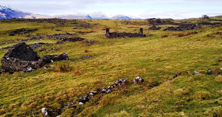
On your way down a sign will point you to Achnacroish Pier. Continue ahead to a gate on your left and then through a long field. Over to your right are the ruins whose inhabitants, or at least most of them, are thought to have died tragically of typhus. There is a wall in the distance and, as you approach it, you will see a sturdy stile at the right hand not far from where it begins to climb a hill.
6. Balnagown and Achnacroish again
You are now in Balnagown looking south to Achnacroish. Stay in the lee of the hill until you see a gentle incline. Go up and along the cliff edge above the raised beach. Ahead is a wooden stile and immediately after the stile on the left is a steep-ish narrow sheep path down to the raised beach. You can go down here or carry on a little to an easier way. On the raised beach ahead is the old flax mill with the millrace to negotiate. In spate this can be a problem, but halfway between the flax mill and the sea is a place you can step across, even when in spate.
It’s all quite wet in places but once across head for Stoker’s Cottage on the shore. On your right you will see the old meal mill and The Mill farmhouse, long the home of the Stewart family. Behind Stoker’s is a red kissing gate. Follow the path towards the large memorial above the sea, known locally as The Monument, which commemorates the drowning of Waverley Arthur Cameron in a yachting accident on 4 June 1891. It was erected by his father, Duncan Cameron, founder of the Oban Times. To approach it you cross what is usually a stone bridge, but which was slightly under water on this occasion.
Continue up to the monument and to another kissing gate just beyond it, and towards Achnacroish on a well-defined path which is wet in places. The last kissing gate just before the houses has been partially demolished by a tree. A path leads in front of the houses and returns you to the old pier with the new slip in front of it.


Further information and links