| Heritage Centre—Port-na-Mòr-Laoch—Creagan Breac | Moderate | 2:35 | 3.92 mi |
|---|
1. HERITAGE CENTRE—PORT A’ CHARRAIN
Take the gate beside the Heritage Centre into Port a’ Charrain and walk diagonally up a gentle hill not beside but parallel to a wall, making towards the left of some trees ahead.
With plenty of good sheep paths, in about 440 metres you reach a gate with a wire strung across the top. If there are lambs about keep well clear of them (and any cattle) as you walk diagonally towards another gate in the corner of the field where three walls meet.
Through this gate you join a well-defined track which is the road to Port Castle.


Very soon, just off the road on your left, is a ruined settlement which is in sharp historical contrast to a modern unfinished house, a second home, up the field at Balimackillichan. (If you want to include the lost village of Port a’ Charrain you can make a short detour walking due south towards a wall with a stile.)
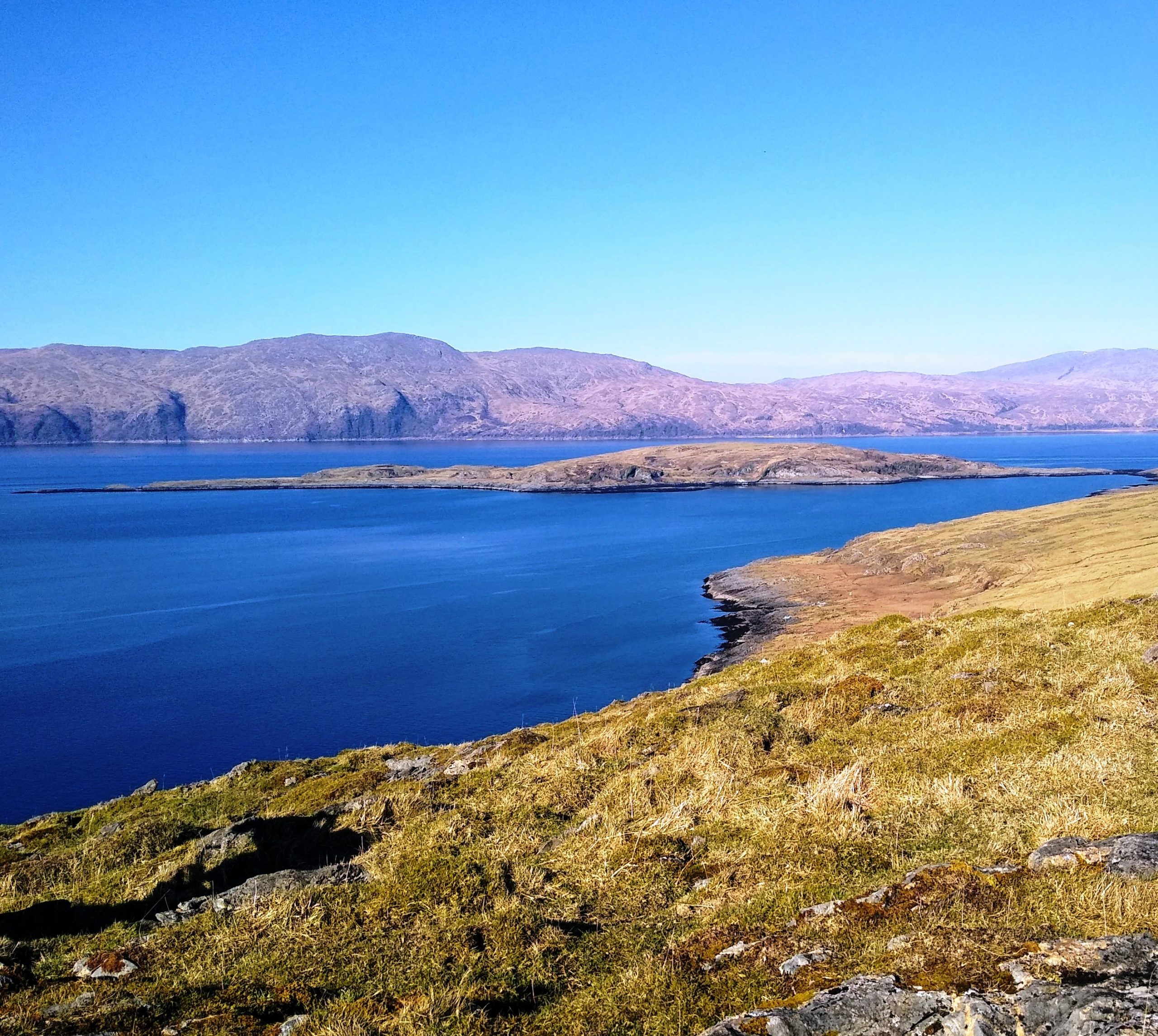
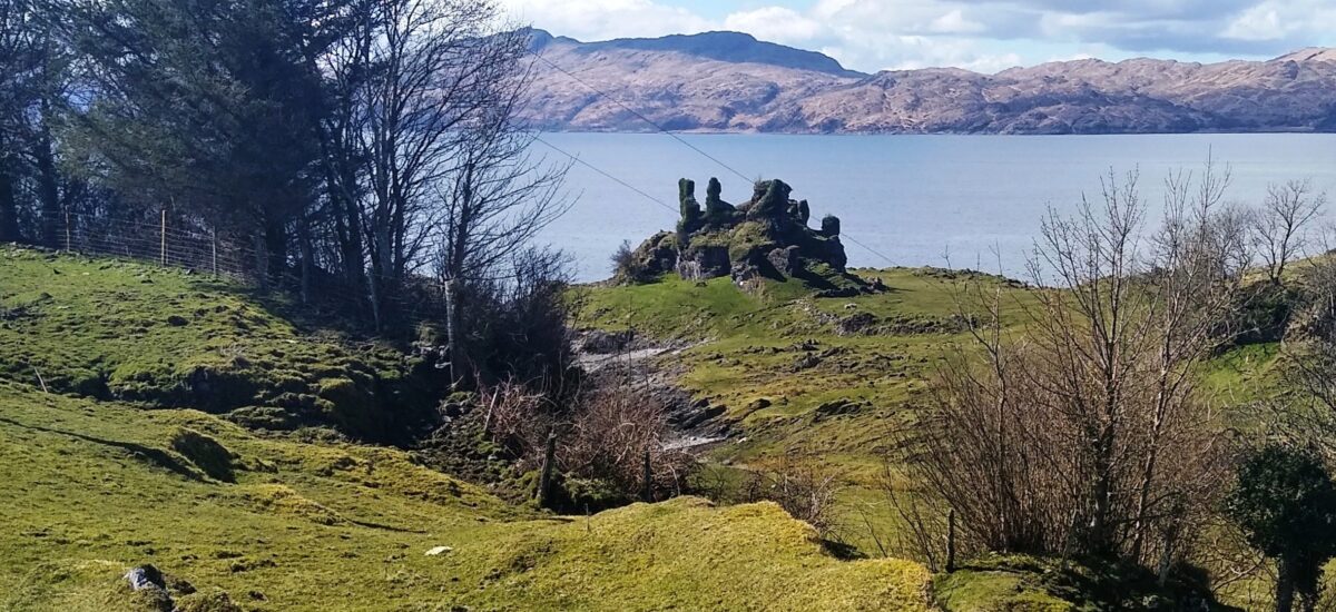
2. PORT CASTLE—CASTLE COEFFIN
Rejoin the road to Port Castle, following it round with Castle Coeffin ahead and, after the Welcome to Port Castle Croft sign, a gate will lead down the hill quite steeply, with the croft house and the equestrian training area on your right.
After two more gates—always leave them as you find them—you can turn off the road and cross the field towards the medieval fish trap beneath the castle.
If the tide is low the fish trap will be visible. Otherwise, follow the track round and turn right onto the raised beach heading north.


The MacDougalls built Castle Coeffin in the 13th century and there is some evidence of earlier Iron Age activity. Historic Environment Scotland care for it now and ask visitors not to climb it; its precarious state is a danger to the castle and the climber.
Continue walking between the sea and the attractive cliffs. When you come to a fence, climb up and go through a gap and then a gate. Follow the path round to the left but when it bears right go straight ahead, staying near the sea.
Go through a gate and then another with a wooden bar above it. Climb up and begin to walk towards the cliffs opposite and then straight ahead on sheep paths. This eventually becomes a sort of track which climbs gently towards a large tree with a ruin beside it. (Ignore a lower gate into a fenced-off field).
The ruin faces south with a clear view past Coeffin to Bernera. The track continues through a very peaceful glen where you may see horses and sheep.
Further on, it joins a road/track coming down from Balimackillichan and continues south as a track (once a road) to Port-na-Mòr-Laoch. This area can be fairly wet.


3. PORT-NA-MOR-LAOCH
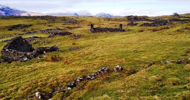
As you approach the port, a ruin lies to the left where presumably the lime works’ manager lived and ran the business. (If you know better, please advise.)
Port-na-Mòr-Laoch (the port of the great heroes) is quiet now but was once very important for fishing, lime and general cargo. It was the main thoroughfare for goods and people who travelled up through Balimackillichan and Bachuil to the main road. It is said to have been the route for hauling sandstone, landed from Morvern, for the masons working on the cathedral in the thirteenth century.
It is also possibly famous for having been visited by St Columba, as written in Lismore in Alba by Ian Carmichael (a minister of Lismore). He also suggests the Fianna from Ireland: Ossian, Oscar and Fionn, may have landed here. That is too interesting not to mention.
In modern times this port was part of the lime industry, although little is known about this kiln compared to those at Sàilean and Kilcheran.
With an increased demand for lime during the 19th century, kilns were built across Lismore—always below a cliff so the quarried stone could be moved downhill to feed the kiln from the top.
The jetty, which is slowly becoming unrecognisable on the stony beach, would have been busy unloading coal and exporting the lime which were carried by the sailing smacks.
As well as the nearby cottages, there would have been storehouses for coal and explosives.


It’s boggy between the path and the ruins, but worth a look. The dwelling has a fireplace and a bible hole and good views of the two kilns, built at different times, and the sea.
The high quarried cliff is covered in vegetation but it is still possible to see how extensively it was worked. And what hard work it must have been in all weathers.
The track continues above the lime kiln and becomes a sheep path through mainly hazel trees.
Beyond the wood are a fence and a wooden stile which take you between the cliffs and the sea and above another lime kiln which was never used.
Follow the path round and you will see a wall with a stile lying between Port Castle and Laggan. Do not cross it.
Ahead is the peninsula of Alasra, and possibly a large fish farm barge.


4. CREAGAN BREAC
Carry straight on round and up towards a gap into Creagan Breac, and follow a vague track up a hill parallel to the wall. An old still is around here somewhere, but exactly where and when it was operative no one is sure. Stills were common and this is a private place.
When the wall bears left continue straight ahead aiming for where the descending hill on your right flattens out. The vista becomes wide open with a view to Ballachulish and Ben Nevis and across to Morvern and north.
Walk across the flat bit and begin to descend where you will see a ruin tucked into the hillside. The gable end has a large intact fireplace and a bedstead which may or may not have been original.
Pass in front of the ruin and continue straight, keeping within the lea of the slope on your right.
Eventually you reach a very solid wall which has to be climbed as there is no other way. However, it is easy and you are unlikely to damage it or yourself. Like all walls, it is sturdiest near the strainer. However, we never recommend climbing them unless there is no other way.
Before you cross you will see, surrounded by trees, another ruined house which was occupied well into the 20th century by up to eight people. Mysteriously, one child was sent to the hospital in Lochgilphead (although not said to be mentally ill).


5. BALIGARVE
Over the wall you are in Baligarve and heading towards a wooden gate up on your left.
In the distance a farm track heads up a hill. This short section is rough, the terrain uneven and densely verdant, full of heather bushes.
In the field to your right, at lambing time, you may spot a person hanging from a tree, a scarecrow dressed as Jim MacCormick. Hi-vis jackets are very convincing.
Once through the wooden gate head up, veering right to join quite a steep tractor track, the old road to Creagan Breac, with views to Ben Nevis. This leads to Baligarve farm but, where it rounds to the right, continue straight ahead and you will see the top of the Old Schoolhouse and, after a roughish track, pass to its left and through a frail gate onto the main road.
Turn right.


Once on the main road, you pass the Old Schoolhouse, Baligarve farmhouse, Hawthorn House and Bachuil.
Hawthorn House was built by Mary Stewart and her son John in the 1860s. Following the death of her husband, a farmer of Baleveolan, Mary turned her hand to business and became a merchant in order to support herself and her children.
Her granddaughter Lily Stewart, for many years a teacher and some time in Lismore Primary school with Mrs Willis, was the last family member to live there, as the land on which Mary and her joiner son built Hawthorn House belonged to Bachuil.
Scots law states that s/he who owns the land eventually owns the house, no matter who built and paid for it. Lily Stewart died in 2012.


6. CLACHAN AND THE CHURCH
As you approach Clachan, and before the church, there is a water tank on a pedestal and a ruin beside it with a corrugated iron roof.
The Lismore Community Bus, known familiarly as the Granny Bus, was this day in front of the church.
Beside the old graveyard, well worth a visit, are the restored and rehoused medieval grave slabs with information boards, the war memorial and then The Old Manse, now a private house.
In the glebe beside the bungalow, known as The New Manse, is the sanctuary stone to which, according to legend, fugitives fled from the Hill of Justice some miles away.
Opposite is The Smiddy, now a holiday rental. When the island needs a blacksmith s/he comes from Oban.


Clachan is where, in the 6th century, Moluag chose to have his Celtic muinntir and where, around 1200 AD, Duncan MacDougall was instrumental in having the new Diocese of Argyll based on Lismore. They built the chancel of the new cathedral in the second half of the 13th century and dedicated it to St Moluag.
The site though is thought to have had religious significance back to worship in the Bronze Age. Information boards outside the church provide more detail.
The surviving structure, cut down from the medieval chancel, has undergone at least two major refits over the last 250 years, the first in the 1740s and then around 1900, resulting in the present parish church.


Finally, you pass the telephone exchange, the ambulance and fire station, the latter being opened and blessed with some pomp in October 2005, complete with a band of newly-trained retained firefighters to whom we have all been grateful ever since.
The telephone exchange appeared when the telephones became automatic and ceased to require an operator, sometime in the mid-1950s, a reliable source tells me. The builders failed to record the year on either the original build or the extension, possibly done in the late 1970s, when more people could afford the service.
However, telephones came to the island in 1939, when troops were stationed at various island encampments and would have needed them. Telephones also went to the shop, the post offices, the minister at the manse, the nurse (possibly) and subscribers who could afford such luxuries. To those that have, much more will be given.
You are soon able to see the Heritage Centre sign where you began.